Coastal Management Plan
Overview
This project aims to develop a Comprehensive Beach Management Plan for the Atlantic coastline along St. Johns County. The study and plan are intended to document beach management activities county-wide, identify and prioritize the needs and objectives for coastal protection, and provide guidance for future management, project implementation and pre/post storm disaster recovery actions.
Project Details
Project Tasks
- Data Compilation
- Environmental Resources Compilation and Analysis
- Coastal Engineering Analysis
- Options for Erosion Control and Beach/Dune Enhancement
- Economic Impact & Benefits Analysis of the Beaches
- Associated Beach Management Elements
- Development of a Beach Management Plan
Timeline
The project was approved by the Board of County Commissioners in April 2024. The project’s goal is for the BCC to adopt the Coastal Management Plan in early 2026.
Funding
This project is funded entirely by the County.
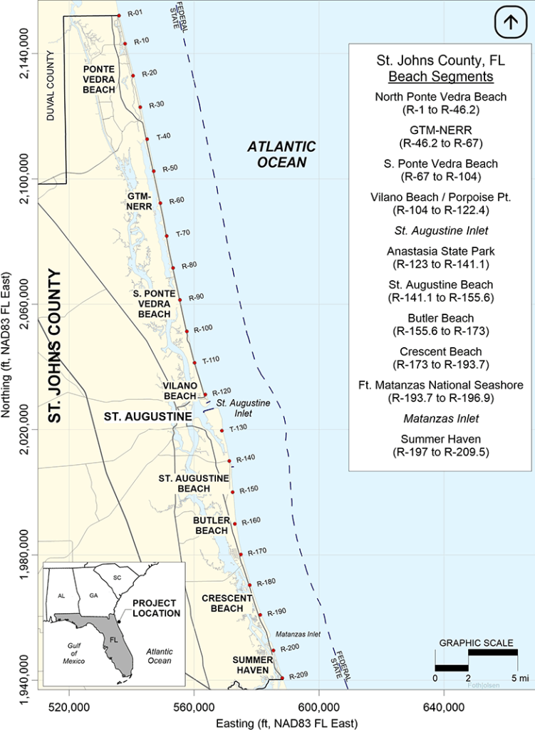
Map Details
This map shows beach segments along the coast of St. Johns County, Florida, with specific geographic markers (R-01 to R-209.5).
- North Ponte Vedra Beach (R-1 to R-46.2)
- GTM-NERR (R-46.2 to R-67)
- S. Ponte Vedra Beach (R-67 to R-104)
- Vilano Beach/Porpoise Point (R-104 to R-122.4)
- St. Augustine Inlet
- Anastasia State Park (R-123 to R-141.1)
- St. Augustine Beach (R-141.1 to R-155.6)
- Butler Beach (R-155.6 to R-173)
- Crescent Beach (R-173 to R-193.7)
- Ft. Matanzas National Seashore (R-193.7 to R-196.9)
- Matanzas Inlet
- Summer Haven (R-197 to R-209.5)